If the buried won’t help us, perhaps the invisible can prove the way. Where the road has lost all substance we must call upon the boundaries of the land it travels through, because ‘a genuine ancient long-distance road is nearly always a parish boundary at least in places,’ claimed Margary.
Having greatly enjoyed Hadley’s Hollow Places, I was eager to catch up with this story of a single Roman road in Hertfordshire and Essex, running 22 km between the small towns of Braughing and Great Chesterford, and coded RR21b by the great Ivan Margary.
The book has roughly one page for each 70 metres of the actual road (depending whether or not you count the notes). For most of its length, the road has simply disappeared to the unaided eye, though cropmarks do show its presence as a straight line between two points. It appears to have cut directly across hills and valleys.
Hadley meditates on the effect of the road, and on its meaning, and speculates about how long it would have taken to construct – and also to destroy; he reckons that locals simply removed most of the stones from which it was made for building. This is a fairly quiet bit of English countryside, and possibly was at its busiest in Roman times.
The emphasis is on the Roman Empire, and how it affected Britain; and on tracing the records of RR21b in maps and elsewhere; and also on the fauna and flora that currently inhabit the fields through which it runs. It’s a great meditation on history and the countryside. With 340 pages (including notes and acknowledgements) that’s about one page for every 65 metres of the road. The illustrations are lovely, though I wish they had been labelled on each page rather than referenced in the endnotes. You can get The Road here.
Second paragraph of third chapter (“Fortified Settlement in Northern Pictland”, by Gordon Noble):
The 5th and 6th centuries in northern Britain are a key period when historical sources increase in frequency for the societies that had lived north of the Roman frontier (Chapter 2 of this volume; Evans 2008, 2014; Fraser 2009a; Woolf 2007b). The literary sources suggest that this was a transformative period with the emergence of more developed systems of rulership and social structure. Important changes can also be identified in the archaeological record in this same chronological horizon: for example, after more than 1,000 years of very limited burial evidence, the dead become a more prominent part of the archaeological record (Chapter 5 of this volume; Maldonado 2013; Mitchell and Noble 2017). As well as cemeteries, memorials to the dead and traditions of monumental carved stone monuments emerged and played notable roles in creating and maintaining new forms of personal and group affiliation (e.g. Forsyth 1997a, b; Goldberg 2012, 155-9; Henderson and Henderson 2004; Samson 1992).
A short book of essays about the Picts, more specifically the archaeological remains that exist in the land to the south of the Moray Firth as far as Aberdeenshire, the ancient realms of Fortriu and Ce. I must say it is surprising just how little is known about this culture; there’s a little bit of “No one knows who they were or what they were doing“. They seem to have left no written records of their own at all. One of the few contemporaries to write about their attitude to Christianity was very negative:
…ecclesia plorat et plangit filios et filias suas quas adhuc gladius nondum interfecit, sed prolongati et exportati in longa terrarum, ubi peccatum manifeste grauiter impudenter abundat, ibi uenundati ingenui homines, Christiani in seruitute redacti sunt, praesertim indignissimorum pessimorum apostatarumque Pictorum.
…the church mourns and weeps for its sons and daughters whom the sword has not yet slain, but who were taken away and exported to far distant lands, where grave sin openly flourishes without shame, where freeborn people have been sold off, Christians reduced to slavery: slaves particularly of the lowest and worst of the apostate Picts.
That’s St Patrick, in his Letter to Coroticus, from the fifth century; though it’s clear that the Picts ended up Christian like everyone else.
The single most fascinating artifact for me is the Rhynie Man, found at what seems to have been a major political/cult centre along with other decorated stones, a life-sized figure carved onto a megalith, now casually sitting in the headquarters of Aberdeen Council. All ancient art is interesting, but human figures are particularly compelling; was the Rhynie Man a portrait? a memorial? a deity? all three? Fourteen centuries on, he is ignoring us and ready to use his axe – on what?
Though the Gaulcross Hoard is fascinating as well, a hundred or so worked silver pieces from the end of the Roman Empire; and the Rhynie Man is but the most striking of many Pictish symbols stones. But it makes you think of the Silurian hypothesis; the Picts had a thriving material culture and presumably everything else that goes with that – yet we do not even know their name for themselves with certainty.
As my regular reader knows, I have done a few road trips over the last few years to visit all the surviving menhirs of Belgium. (I grew up calling them “standing stones”, which is the usual UK / Ireland terminology, but local practice is to use the French term “menhir” which originates from the Breton for “long stone”, though apparently in modern Breton the completely different word “peulvan” is used.)
I’ve exhausted Belgian resources in this regard – the excellent Megalithic Portal lists several that I have not visited, but expresses serious doubt about whether any of them are real megaliths. But there is still plenty to look at in the neighbourhood. I had been tipped off by Herman Clerinx’s Roman book to the joys of Luxembourg, and a bit of research indicated that there was enough there to tick many of my antiquarian boxes.
So on Tuesday, the hottest day of the year so far, I set off down south for a long afternoon.
Diekirch: the necropolis and the museum
My first stop was the northern Luxembourgish town of Diekirch. It has a local beer, an obsession with donkeys, a museum of military history, a museum of historic motor vehicles, and a museum of the history of brewing. But I was not there for any of those. In the 1960s, excavations under the Church of St Lawrence revealed that it had been built on top of a Gallo-Roman necropolis, an indoor cemetery; and a block away a nearly intact large Roman mosaic was found in 1950.
The necropolis, with one of the deceased residentsThe mosaic
The church is free, but to access the necropolis and mosaic you have to pay a very modest entrance fee to the Diekirch History Museum, which I warmly recommend. The museum is very accessible and friendly. Unfortunately all the displays are in German; there are leaflets available in other languages but they really don’t cover much of the content.
Deiwelselter
On a rock outcrop overlooking the town of Diekirch is the site of what used to be a megalithic dolmen, the Devil’s Altar or Deiwelselter in Luxembourgish. From the number of stones, it must have been about half the size of the big Wéris dolmens, far bigger than the Irish ones that I grew up with. Unfortunately, in 1892 the city fathers of Diekirch decided to rearrange the stones into a large arch shape, completely destroying the existing structure. God save us from the arrogance of the nineteenth-century antiquarian.
It’s quite a hike to get to as well. I am afraid that I ignored the ‘No Entry’ sign at the bottom of the lane, and parked at the edge of a field. Today’s city fathers of Diekirch could profitably think about improving access.
Beisenerbierg
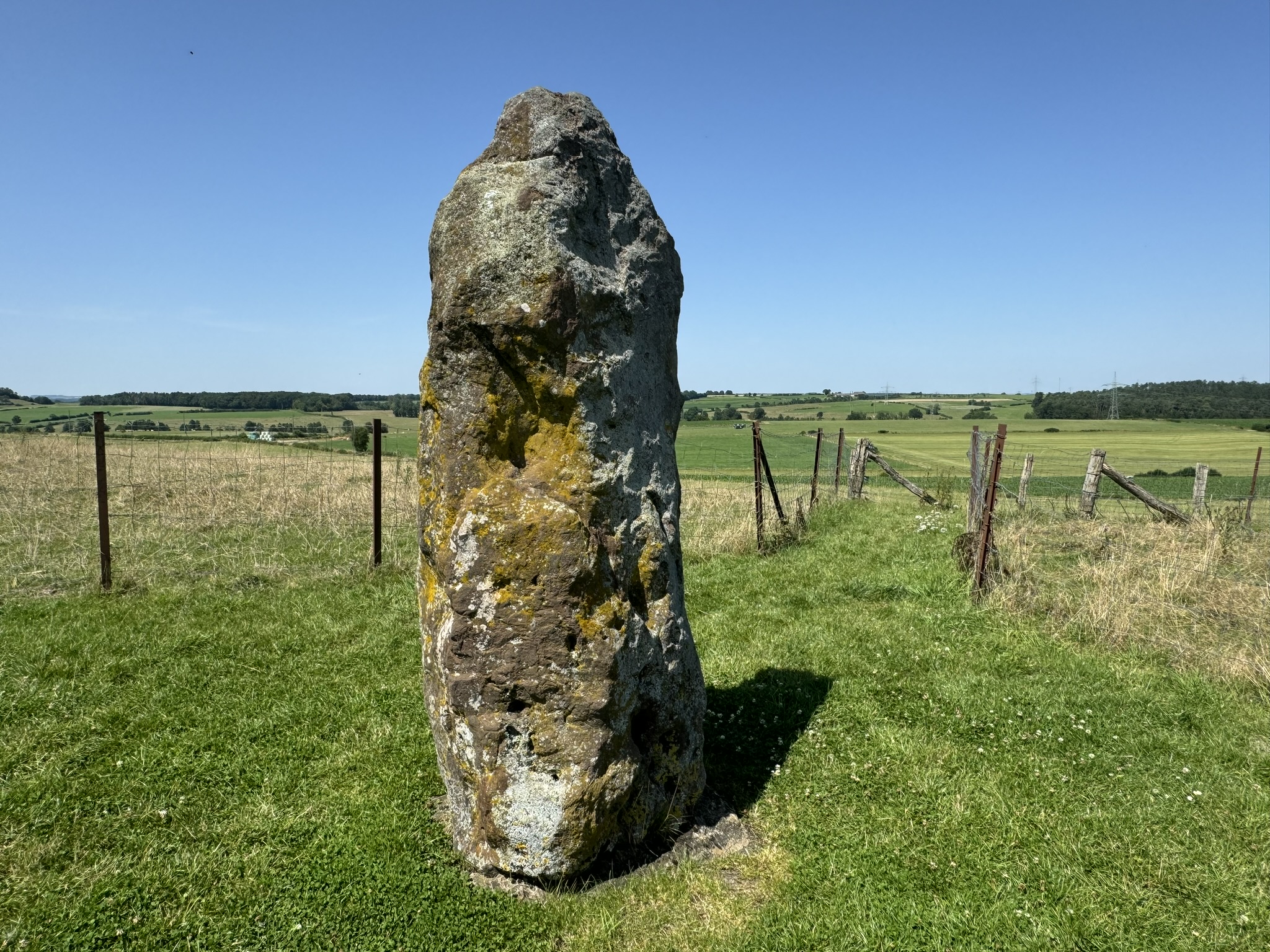
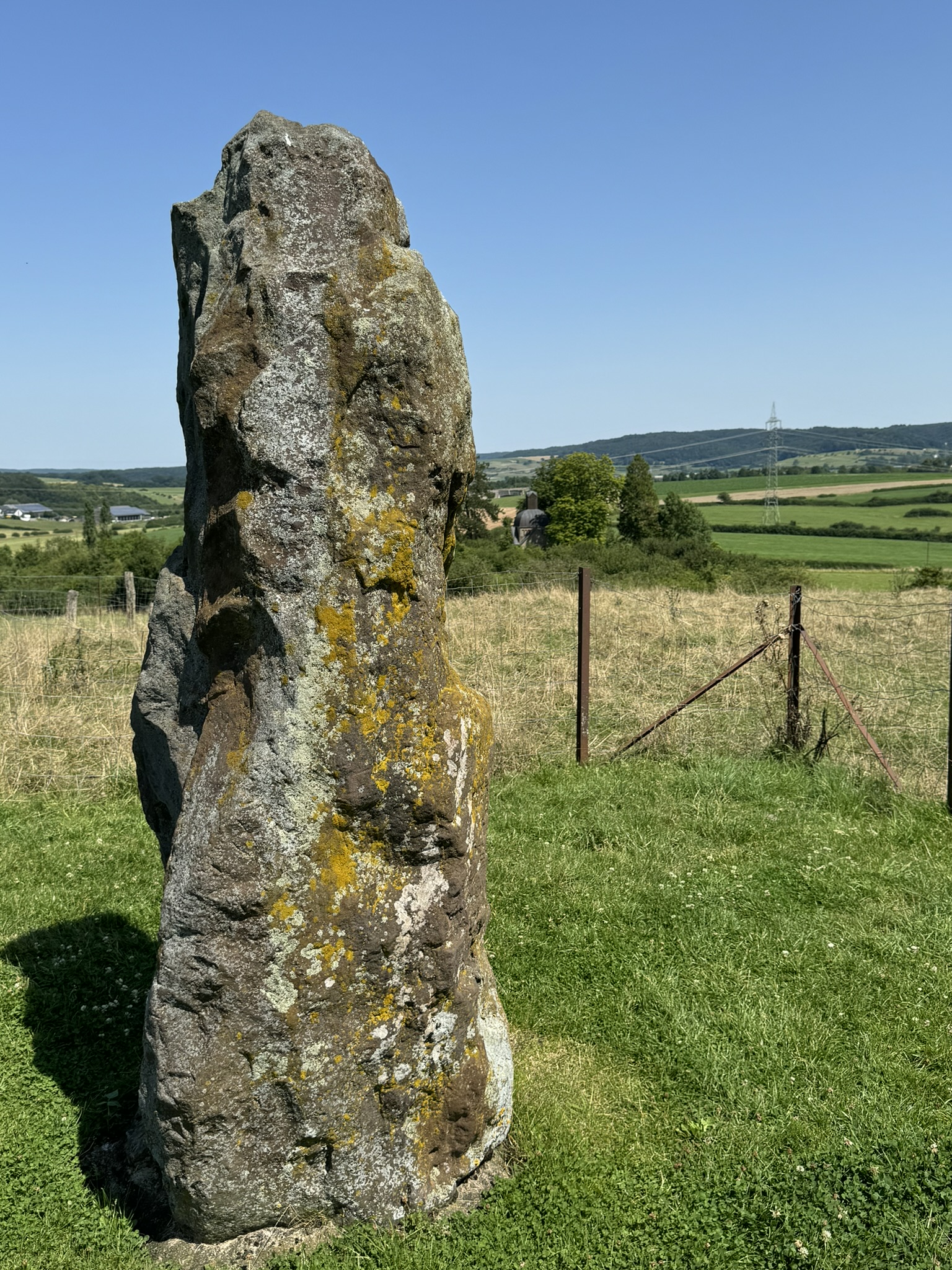
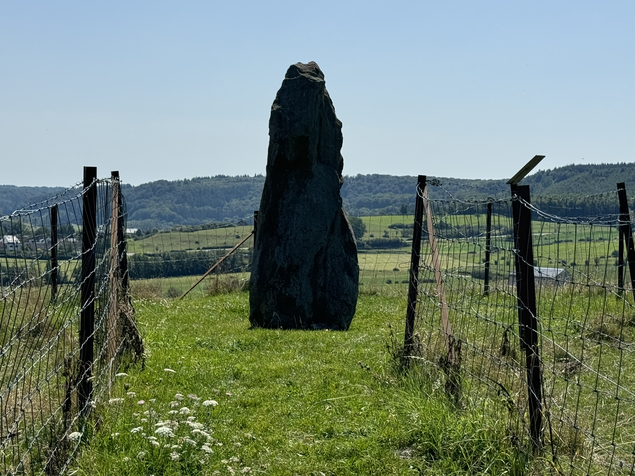
The only genuine menhir surviving in the whole Grand Duchy of Luxembourg is near the town of Mersch. It was buried until 1978 and then erected on its present location, 30 metres from where it was found. It’s unusual among menhirs in that it’s on top of a hill – usually they are on the flank of a slope. Some commentators claim to see an anthropomorphic shaping of its profile; I am not convinced myself, but see what you think.
Of the four monuments I tracked down in the field, this was by far the easiest to find – you park in a layby by a 17th century chapel, and then the path from the chapel is pretty obvious. (And it’s interesting that although the stone itself was buried for centuries, Christianity built a shrine nearby.)
Häerdcheslee/ La Roche des Payens
I have never seen anything quite like this before.
Here are two figures carved into a sandstone boulder on a hillside. In the rock above them is a rectangular pit (which I am not athletic enough to access). Are they gods? A funeral memorial? Who knows? Nearby rock show signs of stone-age grooves, but the Häerdcheslee figures are dated firmly to the first century AD (…ish).
In his novel L’homme qui rit, Victor Hugo makes a passing reference to:
…la clairière dite la Mauvaise Femme, près Diekirch, où il y a deux bas-reliefs énigmatiques représentant une femme qui a une tête et un homme qui n’en a pas…
…the clearing called “The Wicked Woman” near Diekirch, where there are two mysterious sculpted figures representing a woman with a head and a man without one…
It’s not all that close to Diekirch, and I think I’d say the headless figure is more likely to be female, but he’s clearly talking about the same place.
It’s not well signposted at all, but as long as you have the coordinates you will find it.
Raschpëtzer Qanat
The Raschpëtzer Qanat is a 600 metre long tunnel, built around 130 AD, which brought water from a spring on one side of the Petschend hill to a large Roman villa in the Alzette valley on the other side. It is an extraordinary feat of engineering. At least eighteen shafts were dug from the hillside down to the channel below. The mysterious pits on the hill were known about for centuries, but the water channel was only rediscovered in 1986.
One of them has been lit so that you can see all the way down to the water flowing at the bottom.
My cousin J lives in Luxembourg, close to the Qanat, and joined me for the trip. “I’ve lived in this country for ten years, we are less than ten minutes’ drive away, and I’d never been here before!”
There is a visitors’ gallery to the tunnels which is supposedly open only on Sunday afternoons; but we were lucky and found it open on a Tuesday.
From the top of the hill there is a lovely view of the towns of Heisdorf and Steinsel.
This is impressive engineering, and the best example of this sort of water management system north of the Alps, but in fact the emperor Claudius (remember him?) had set up a similar and much bigger structure to drain the waters of Lake Fucino in Italy about 80 years earlier (including what was the longest tunnel in the world, until 1871), and it is on record that this was repaired at almost exactly the same time that the Raschpëtzer Qanat was built, so the technology was available within the Roman Empire.
The Raschpëtzer Qanat is not very well signposted (a familiar refrain) from the car park, but if you use online resources you can find your way fairly quickly. A fellow rambler told us that there used to be more and better signs, so perhaps by the time you get there the situation will have improved again. And on such a warm day it was nice to spend so much time in the woods with their natural air conditioning.
Food and language
Always worth noting where I ate – you may want to follow suit. In Diekirch I had lunch at Niklos Eck, an unpretentious Luxembourgish eatery at 3 rue Nicolas Wathelet – actually on the square around the corner from St Laurence’s Church and the museum. The lentil and sausage salad was yummy and kept me going all afternoon. It doesn’t have a website, you’ll just have to show up and hope for the best.
For dinner, J. took me to Um Eck in Hostert, which apparently has upgraded significantly in the most recent period and did a rather good seafood platter – the calamari were a bit chewy but that’s tricky to get right for the first customers of the evening, and the rest was very yummy.
Everyone speaks French and German in Luxembourg, and most people speak English; and if your German is good enough you can catch most of what is written or spoken in Luxembourgish as well. It’s one of those situations where making all the languages official and legal has taken the sting out of the cultural issue.
So, I don’t think I need to go back to Luxembourg for the sake of the antiquities, but I am glad I went. (And it’s always nice to spend time with J.)
The man who did the most to define the edges of the Roman state was its first emperor, Augustus (27 BC-AD 14). Towards the turn of the Era he completed the conquest of the Alps and Spain, defined the eastern boundary by treaty with the Parthians, sent expeditions up the Nile and into the Sahara Desert, and brought Roman arms to the Danube and the Elbe. He famously gave advice to keep the empire within its present boundaries; advice conspicuously ignored by many of his successors, though their achievements were much less than his.
De man die het meest heeft gedaan voor het vastleggen van de grenzen van het Romeinse Rijk was de eerste keizer, Augustus, die regerrede van 27 voor tot 14 na Christus. Rondom het begin van de jaartelling had hij de Alpen en Spanje veroverd, legde hij de grens in het oosten vast door en verdrag met de Parthnen, zond expedities naar de Nijl en de Sahara and trok hij militair op naar de Donau en de Elbe. Het is bekend dat hij adviseerde het rijk binnen deze grenzen te houden. Dit advies is door veel van zijn opvolgers in de wind geslagen, hoewel zij op minder successen konden bogen dan hij.
Der Mann, der am meisten für die Festlegung der Grenzen des römischen Staates getan hat, war der erste Kaiser, Augustus (27 v.-14 n. Chr.) Um die Zeitenwende schloss er die Eroberung der Alpen und Spaniens ab, bestimmte in einem Vertrag mit den Parthern die Ostgrenze, sandte Expeditionen auf den Nil und in die Sahara und brachte römische Heere and die Donau und die Elbe. Er ist berühmt für seinen letzten Rat, das Reich innerhalb der damaligen Grenzen zu halten; einen Rat, den viele seiner Nachfolger offenkundig ignorierten, obwohl ihre Leistungen viel geringer waren als seine.
This is a lovely wee book, produced by the team publicising the recent recognition by UNESCO of the Roman frontier on the lower Rhine as a World Heritage Site. It is lavishly illustrated with photos, charts and maps of the Roman Empire’s frontiers, not only of the lower Rhine but also from Hadrian’s Wall, the Sahara and everywhere in between. The text is in three languages, all impressively squeezed together to fit the photographs.
The authors make the points that the Roman frontier on the Lower Rhine stayed pretty much in the same place for the lifespan of the Empire, and that the soil and social conditions have allowed a lot of archaeological sites to remain in a good state of preservation. I picked up a hard copy of the book at the summer party held by the Brussels office of North Rhineland-Westphalia, which is in the same building as my own workplace, but you can download it for free here.
The one photo that particularly grabbed me was not from Germany or the Netherlands, but from England, the “Staffordshire Pan“, a copper bowl which appears to be a Roman-era souvenir of Hadrian’s Wall. It is decorated with mock Celtic motifs and has the names of the four westernmost forts on the Wall written below the rim, along with the name ‘Aelius Draco’, who might have been the maker or (I think more likely) the person for whom it was commissioned. Originally there would have been a handle, though it looks too beautiful to actually cook with. It was found in Staffordshire in 2003 and is now on display in Carlisle.
Looking for culture on the public holiday last Monday, I found that most of the fine arts museum in Brussels were closed, but the Gallo-Roman Museum in Tongeren was open. It was a very long time since we last visited, so I headed off to explore; it’s an hour’s drive from us and I didn’t persuade anyone else to come with me.
I really enjoyed it. It actually starts from the Neanderthals and works through my old friends the Michelsbergers before getting to the Celts and Romans. Tongeren was the biggest Roman town in what is now Belgium and they have a lot of archaeological finds.
As so often, I was especially struck by the three-dimensional representations of the human body. This is Amor and Psyche cuddling, with Mercury looking on from behind – very small figures all three.
Here’s an even smaller but very cute lamp oil holder.
Here is (headless) Jupiter trampling two men with tentacles for legs. I am impressed by the expression on the face of the first tramplee.
Here is a broken vase from a household shrine which would have originally had seven face representing the seven planets who give their names to the days of the week.
Here is a very characterful Venus, on loan from the Vatican collection. You can see that her right arm would originally have crossed her chest to rest her hand on her left arm, and her left hand would have been modestly on her right thigh.
There is also a temporary exhibition making the argument that most of the classical statues were brightly painted, and extrapolating from the traces of pigment left on them. I don’t know how reliable this is, but the results are certainly striking. Here, for instance, is the proposed original appearance of Augustus:
13,000 years ago, a puppy was born in what is now Germany. The puppy was not healthy, and had to be nursed by its humans through three bouts of distemper when it was four to five months old. That is a disease that still kills dogs, especially puppies, to this day.
Sadly, when it was about six months old, the puppy died. It was found in Oberkassel near Bonn in 1914, along with two humans, a woman in her mid twenties, and a man aged about forty. They were all buried with honour and ceremony, sprayed with red rock powder, covered with basalt blocks so that nobody would disturb them.
We don’t know much more than that. We know that the the two humans were related, but not closely. We know that a tooth from another dog was buried too, along with a carved bone pin, a sculpture of the head of an elk carved into an elk antler, a bear’s penis bone (lots of male animals have penis bones, though humans don’t) and a red deer tooth. No other humans or animals were buried in the immediate area.
It seems to me that the most likely scenario is that the two humans were leadership figures in their village, their clan, their tribe, whatever the larger social unit was. He had a couple of healed broken bones. She had had at least one child. They both had bad teeth. There’s no obvious cause of death – no marks of immediate violence.
I would bet that man, woman and dog died together in an accident that left no trace on their bones; asphyxiation caused by fire or flood, perhaps. And their grieving kin laid all three of them to rest together, speaking words we can never hear, in a language we will never know, for them to be found 14,000 years later.
The Oberkassel puppy is the earliest known example of a domesticated dog. It was ill for much of its short life, and could not have been useful to its humans as a hunter or guard. They spent a lot of time looking after it, because they loved it.
Don Hitchcock’s web page has lots more information, links and photographs. The best recent academic source on the Oberkassel puppy is by Luc Janssens of the University of Gent and colleagues: “A new look at an old dog: Bonn-Oberkassel reconsidered”, Journal of Archaeological Science (2018), https://doi.org/10.1016/j.jas.2018.01.004.
Here I am, at the age of nineteen, at the bottom of a ditch. I spent four months in the summer of 1986 working on an archæological site near Heilbronn in Germany, in the village of Klingenberg, as a volunteer on the payroll of the Land of Baden-Württemberg. (Actually the only time in my life when I have been directly paid by the taxpayer, though I’ve had plenty of taxpayer-funded work since.)
The site was a promontory fort that had been identified by cropmarks in photos taken a few years earlier. Two curved ditches had cut off the end of the hill from potential invaders. The excavation, overseen by the genial Dr Biel, was to record and rescue the remnants of a mesolithic settlement of the Michelsberger culture before a housing estate was built on it. (Pictures are from Dr Biel’s article, which is in German.)
The field, incidentally, belonged to the Count of Neipperg, who died last year at the age of 102. In the summer of 1986 he was in his mid-sixties, and would occasionally drop by to keep an eye on things. His great-great-grandfather, the dashing Adam Albert von Neipperg, famously seduced and later married the Empress Marie-Louise, Napoleon’s second wife. (The Count who I knew was descended from Adam Albert by his first marriage.)
Archæology has a dreadful career structure. I was doing it to scratch an itch in my year off between grammar school and university, and never planned to go into it long term. But it’s truly fascinating to find artifacts left behind six thousand years ago. Some of the clay from buildings or ceramics still had visible thumbprints made by people who died a thousand years before Stonehenge was built. It makes you think.
The picture at the top was taken by my then colleague Jan Grabowski (who has since become rather well-known for other reasons) as we created a rather wonderful thing under the direction of Dr Biel: we took transverse sections of each of the defensive ditches, and then placed canvas against them, splashed varnish over the canvas liberally to make it stick to the exposed soil, let it set and then peeled away the canvas with the soil still sticking to it, to preserve the appearance of the transected ditch. The varnish fumes got quite overpowering and we were allowed only a minute or so in the pit at a time. I’m in the less exciting outer ditch; both are on display in the museum in Stuttgart.
It may not be clear from the above, but the end of the settlement at Klingenberg was not a happy one. The black marks from the inner ditch are the remains of a burnt palisade, which had broken and fallen inwards. At the bottom of the ditch we found an enormous aurochs horn, which mush have adorned the fortification as a show of strength to outsiders, ultimately unsuccessful. We found one corpse untidily dumped in a rubbish pit. A forgotten conflict, whose only remaining record was the marks in the soil and the charcoal in the ditches. As I said, it makes you think.